
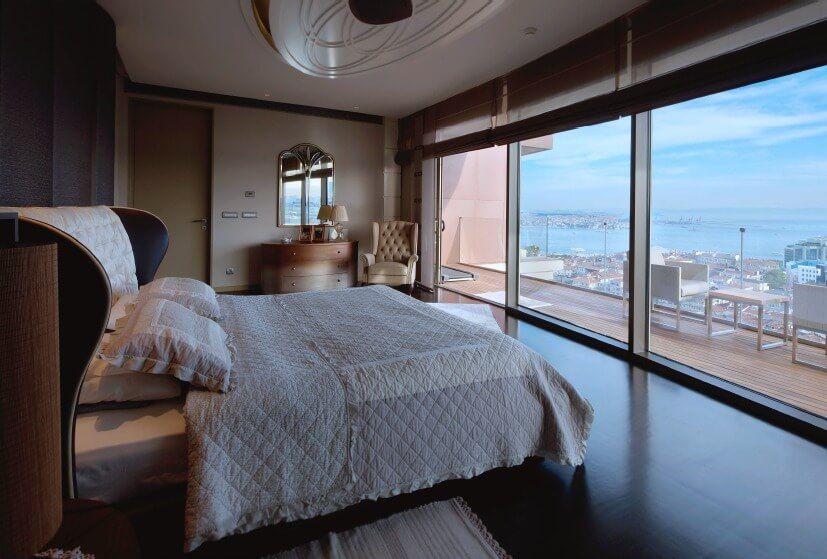
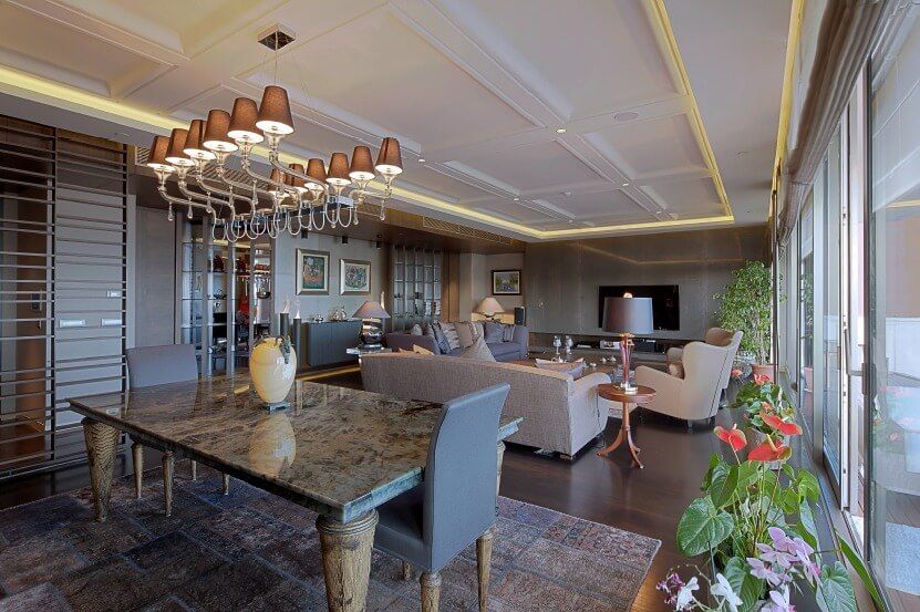
Bosphorus View Macka Residence


- City: ISTANBUL PROPERTY
- Property type: Apartment
- Bedrooms: 3
- Offer type: Bosphorus View Residence
- Neighborhood: Beşiktaş
- Bathrooms: 4
- Property size: 410 m²
- Property ID: 15755
Features
- Administrative support
- Balcony
- Cafe
- Central heating
- Dishwasher
- Gym
- Investment properties
- Kitchen
- Luxury Property
- Reception services
- Restaurant
- Sauna
- Security System
- Swimming Pool
Details
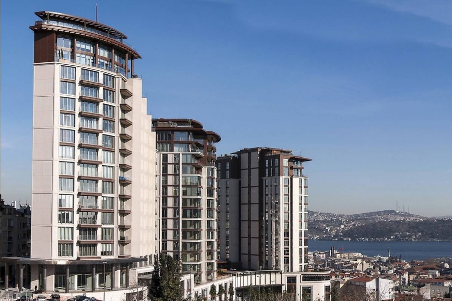
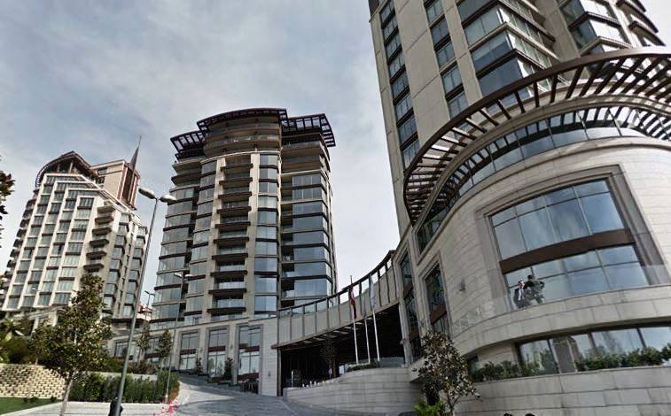
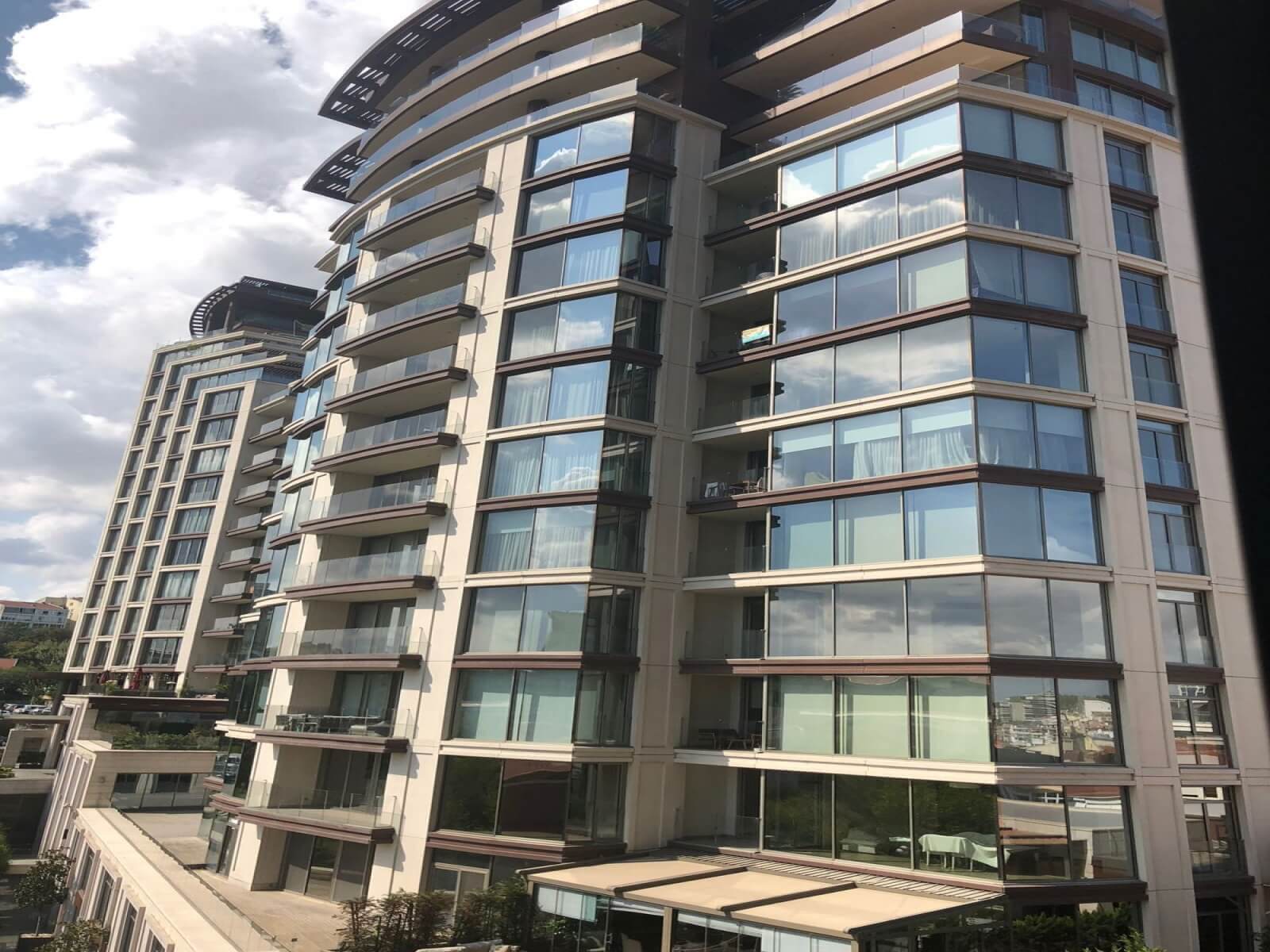
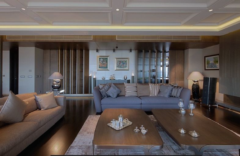
Bosphorus View Macka Residence
3.5 + 1 Luxury Flat with Bosphorus View in Istanbul
The project, which consists of 170 houses in 3 blocks with 12 and 14 floors, has 10 different types of residences and a 3 thousand square meter social facility. In the project where flats overlooking the Bosphorus Bridge, the Islands and the historical peninsula are located, the project attracts attention with its location and luxury products used in the flats.
Project Type: Residence
Number of residences: 170
Land Area: 7300 m2
Housing Types: 1 + 0, 1 + 1, 2 + 1, 3 + 1, 4 + 1
Square Meters Area: 135 – 500 m2
Delivery Date: Immediate Delivery
Site Features
Outdoor swimming pool
Indoor swimming pool
Sauna
Turkish bath
Fitness center
Shopping Mall
Cafe
Restaurant
Security
Camera security
Sea view
Bosphorus view
Parking Garage
Sun terrace
Building Features
Water tank
Booster
Generator
Elevator
Freight elevator
Lightning rod
Lobby
Luxury Feature Reception
Sprinkler system
Housing Features
Built-in white goods
Intercom system
Central heating
Heat share meter
Central air conditioner
Parents’ bathroom
Parents’ dressing room
Terrace
Balcony
Construction Techniques
Building inspection
Ground survey done
Compliant with earthquake regulations
In compliance with the insulation regulation
Raft foundation
Bosphorus
Jump to navigationJump to search
| Bosphorus Strait İstanbul Boğazı |
|
|---|---|
|
Bosphorus Strait
İstanbul Boğazı |
|
| Coordinates | 41°07′10″N 29°04′31″ECoordinates: 41°07′10″N 29°04′31″E |
| Type | Strait |
| Part of | Turkish Straits |
| Basin countries | Turkey |
| Max. length | 31 km (19 mi) |
| Min. width | 700 m (2,300 ft) |
| Max. depth | 110 m (360 ft) |


A map depicting the locations of the Turkish Straits, with the Bosporus in red, and the Dardanelles in yellow. The territory of Turkey is highlighted in green.

Location of the Bosporus (red) relative to the Dardanelles (yellow) and the Sea of Marmara.

Close-up satellite image of the Bosporus strait, taken from the International Space Station in April 2004. The body of water at the top is the Black Sea, the one at the bottom is the Marmara Sea, and the Bosporus is the winding waterway that connects the two. The western banks of the Bosporus constitute the geographic starting point of the European continent, while the banks to the east are the geographic beginnings of the continent of Asia. The city of Istanbul is visible along both banks.

Aerial view of the Bosporus taken from its northern end near the Black Sea (bottom), looking south (top) toward the Marmara Sea, with the city center of Istanbul visible along the strait’s hilly banks.
The Bosphorus Strait (/ˈbɒspərəs, ˈbɒsfərəs/;[a] Ancient Greek: Βόσπορος Bosporos [bós.po.ros]; Turkish: İstanbul Boğazı ‘Istanbul strait’, colloquially Boğaz) or Bosporus Strait is a natural strait and an internationally significant waterway located in northwestern Turkey. It forms part of the continental boundary between Asia and Europe, and divides Turkey by separating Anatolia from Thrace. It is the world’s narrowest strait used for international navigation.
Its water drainage consists of: The Sea of Azov (Ukraine & Russia) → Kerch Strait → The Black Sea (Turkey, Bulgaria, Romania, Ukraine, Russia & Georgia) → Bosphorus Strait (Turkey) → The Sea of Marmara (Turkey) → Dardanelles Strait (Turkey) → Aegean Sea (Greece & Turkey) → Mediterranean Sea → Atlantic Ocean
Most of the shores of the Bosporus Strait, except for those in the north, are heavily settled, straddled by the city of Istanbul‘s metropolitan population of 17 million inhabitants extending inland from both coasts.
The Bosporus Strait and the Dardanelles Strait are known as the Turkish Straits.
Name
The name of the channel comes from the Ancient Greek Βόσπορος (Bósporos), which was folk-etymologised as βοὸς πόρος, i.e. “cattle strait” (or “Ox-ford”[b]), from the genitive of boûs βοῦς ‘ox, cattle’ + poros πόρος ‘passage’, thus meaning ‘cattle-passage’, or ‘cow passage’.[7] This is in reference to the mythological story of Io, who was transformed into a cow, and was subsequently condemned to wander the Earth until she crossed the Bosporus, where she met the Titan Prometheus, who comforted her with the information that she would be restored to human form by Zeus and become the ancestress of the greatest of all heroes, Heracles (Hercules).
The site where Io supposedly went ashore was near Chrysopolis (present-day Üsküdar), and was named Bous ‘the Cow’. The same site was also known as Damalis (Δάμαλις), as it was where the Athenian general Chares had erected a monument to his wife Damalis, which included a colossal statue of a cow (the name δαμάλις translating to ‘heifer’).[8]
The English spelling with -ph-, Bosfor has no justification in the ancient Greek name, and dictionaries prefer the spelling with -p-[a] but -ph- occurs as a variant in medieval Latin (as Bosfor, and occasionally Bosforus, Bosferus), and in medieval Greek sometimes as Βόσφορος,[9] giving rise to the French form Bosphore, Spanish Bósforo and Russian Босфор. The 12th century Greek scholar John Tzetzes calls it Damaliten Bosporon (after Damalis), but he also reports that in popular usage the strait was known as Prosphorion during his day,[10] the name of the most ancient northern harbour of Constantinople.
Historically, the Bosporus was also known as the “Strait of Constantinople”, or the Thracian Bosporus, in order to distinguish it from the Cimmerian Bosporus in Crimea. These are expressed in Herodotus‘s Histories, 4.83; as Bosporus Thracius, Bosporus Thraciae, and Βόσπορος Θρᾴκιος (Bósporos Thráikios), respectively. Other names by which the strait is referenced by Herodotus include Chalcedonian Bosporus (Bosporus Chalcedoniae, Βοσπορος της Χαλκηδονιης [Bosporos tes Khalkedonies], Herodotus 4.87), or Mysian Bosporus (Bosporus Mysius).[11]
The term eventually came to be used as common noun βόσπορος, meaning “a strait”, and was also formerly applied to the Hellespont in Classical Greek by Aeschylus and Sophocles.
Geography
As a maritime waterway, the Bosporus connects various seas along the Eastern Mediterranean, the Balkans, the Near East, and Western Eurasia, and specifically connects the Black Sea to the Sea of Marmara. The Marmara further connects to the Aegean and Mediterranean seas via the Dardanelles. Thus, the Bosporus allows maritime connections from the Black Sea all the way to the Mediterranean Sea and the Atlantic Ocean via Gibraltar, and the Indian Ocean through the Suez Canal, making it a crucial international waterway, in particular for the passage of goods coming in from Russia.
- ID: 15755
- Published: April 24, 2021
- Last Update: August 22, 2022
- Views: 589